According to historical sources and archaeological findings, the Urartians, who formed a part of the history of ancient Anatolia, appeared on the stage of history between the VIII century BC and the VI century BC. It was defined as "Uruatri" in Assyrian sources. It meant high country, mountainous country.
Following this, Uratri, and then Urartu. In the same century, the Nairi principality emerged. They are mentioned in contemporary Assyrian sources. From the IXth century BC onwards, they adopt the Assyrian cuneiform tradition and inscriptions and tablets in their own language are on the agenda. In their own written sources, they identify themselves with the name "Bidini" (li). On the other hand, the names Urartu and Nairi given to them by Assyria are also seen in their own inscriptions.
The Urartu Civilisation was forgotten in a short time and remained in the memory as a nation mentioned only in a few places until research on this subject began. The name Urartu is known from the Torah. (r.r.r_ Ararat) In connection with the Noahic legend, it is mentioned that Noah's ark was seated on Mount Ararat. In another passage there is a little bit of information. In the famous work of Herodotus, they are referred to as "Alarots". Later Late Antique Sources and Medieval historians accepted that all Urartian works of art were made by the Assyrians. For example, Moses of Khoroneli (of Armenian descent), one of the historians of the V century A.D., writes that the city of Van, which rises on the shores of Lake Van, was built by the Assyrian Queen Samiram (Samiramis) and explains the name of the city as the city of Samiramis. According to this author, Samiramis brought 12,000 labourers and 6,000 builders from Assyria and the countries that paid tribute (tribute, tax) to the Assyrians and built this magnificent city in a short time. According to Moses, the great water canal irrigating the plain of Van was also built by the Assyrian Queen Samiramis. (Samiram is Armenian) Moses' work attracted the attention of orientalists in the modern world in the XIXth century.

THE BEGINNING OF URARTU RESEARCH
In 1828, the French Society for the Study of Asia sent the archaeologist Friedrich Eduard Schulz to Turkey. He also travelled in Iran. Schulz visited the Van Castle described in detail by Moses, visited the tombs carved into the rocks, identified them as caves, drew their plans and copied the cuneiform inscriptions. In addition, while exploring the Van Plain, he came across a large water canal mentioned by Moses and claimed to have been built by Samiramis, and copied the inscriptions of this canal, called "Samiram Water" by the local people. Schulz's report caused great repercussions in Europe. It took more than a century to analyse these inscriptions, and only then was the historical truth revealed. Namely, Van Castle, the capital of Urartu, was built by Sardur I. The canal in question was built by Mehud, the grandson of Sardur I. King Mehud defeated Assyrian Queen Sammuramat and had this canal built to meet the water needs of Tuspa and irrigate the Van Plain. The murder of Schulz by bandits while conducting research in the mountainous region prevented the continuation of these scientific studies for a while. The material he sent to Paris in 1828 could only be published in 1840. In the same years, archaeological studies started in Mesopotamia in the Old Assyrian Country. Especially the discovery of the palace of Sargon II in Khorsabat in Assyria and the deciphering of the Assyrian cuneiform script shortly afterwards attracted the attention of the scientific world. Only after this, Urartian cuneiform documents also began to be deciphered. Following these first researches, artefacts from Van and its surroundings began to be brought to museums and private collections through illicit excavations. With the proliferation of these artefacts and the decipherment of the inscriptions, the idea that they belonged to the Urartian kings of Van gained strength. Nevertheless, for a long time, numerous Urartian artefacts were accepted as Assyrian artefacts and presented under this name. Towards the end of the 19th century, illicit excavations in and around Van increased and Toprakkale (Rusahilini) was looted. These illicit excavations fed the British Museum in Europe and the Louvre and Berlin museums in Paris. The proliferation of artefacts necessitated scientific excavations in this region. In 1845, the famous archaeologist and diplomat Henri Layard visited Van and in 1880 he sent his assistant Hormudz Rassam to Van. Both scholars conducted excavations of Assyrian palaces in Mesopotamia and introduced them to the scientific world. In 1879-1880, the British Museum sent a scientific delegation to Van. This delegation was headed by Captain Clayton (Vice Consul), the British Consul in Van. Rassam and an American missionary named Dr Reynolds also participated in the excavations mentioned above. However, the architectural remains and small finds left behind from the excavations carried out by antiquities smugglers did not satisfy this scientific committee investigating Toprakkale. This material was published only 80 years later by the famous British scientist Dr R. D. Barnett. In 1898 and 1899, a scientific team headed by C.F. Lehmann - Haupt and W. Belck excavated Toprakkale again. In 1911-1912, this time Russian scientists were on the scene. An excavation team under the direction of I. A. Orbeli resumed excavations at Toprakkale. Following these years, Van was under Russian occupation between 1915 and 1918. During this war, the Tsarist Russian Archaeological Society appointed Prof. N.J. Marr to Van in 1916. The delegation led by Prof. Marr and Orbeli uncovered the sanctuary and cuneiform inscriptions of the Urartian King Sarduri II on the northern slopes of Van Castle. After the Russian delegation, in 1938, husband and wife Americans conducted research (Kirsopp and Silva Lake). However, the outbreak of World War II affected these studies. These are the first studies in Turkey.

In Soviet Armenia, excavations in South Transcaucasia in the north-eastern regions of the Urartu Kingdom go back to ancient times. Urartian artefacts were first unearthed in 1862, and especially the inscriptions attracted attention. In 1893, M. Nikolskij travelled around Transcaucasia as a traveller and examined the Urartian fortresses near the places where the inscriptions were found. The real archaeological excavations started at the site called Taşburun and the Urartian city was investigated. According to the inscriptions, the fortress bears the name "Menuahinili". Following these excavations, in 1930, these ruins and inscriptions attracted the attention of the scientific world again and in 1939, systematic excavations were started at the mound named Karmir-Blur near the city of Yerevan. These excavations were carried out by Prof. B.B. Protrovski until recently. This great city was founded by Rusa I, the son of Argisti, and was named Teishebaini (Karmir-Blur). Especially the stadel part of this city provided detailed information about Urartian culture and architecture. (Urartian cities were named after their gods or kings. Terşe- God, Tushpa- Goddess). Another excavated centre is located on the hill named Arinberd near Yerevan. Its name is Irpuni (Erebuni) and it is divine. Excavations started here in 1950 and continued by K. Ogehesian. Many construction inscriptions belonging to Menua's son Argishti I and Argishti's son Sarduri I were found here (city, foundation, warehouse inscriptions etc.). Nairi are communities of Huri origin and Uruatri are communities of Urartu origin. Their languages are Asiatic and similar.In 1964; excavations were resumed at Armavir-Blur and Davida mounds near Armavir.

NEW RESEARCH IN TURKEY
The beginning of research in Turkey is as follows. In 1938, the Ankara Archaeological Museum acquired a collection of finds unearthed during the construction of a railway at Altin-tepe, near Erzincan. Among them, a three-legged bronze cauldron, shield and pieces of furniture attracted attention. However, twice in 1956-1957, the British scientist and archaeologist C.A. Burney revisited the castles in the Van region and published their plans. These were published in Anatolien Studies.
The first scientific excavations started in 1956-1963 and continued intermittently. Altintepe excavations were directed by Prof. Dr Tahsin Özgüç. The tombs, temples and small finds unearthed in this excavation are remarkable. The excavations at Toparkkale were carried out in 1950-60-61 by a committee headed by Prof. Dr. Afif Erzen. The foundations of the temple, which had previously been unearthed during the excavations of the British Museum, were analysed in detail. A bronze shield decorated with lion and bull figures attracts attention. (A ceremonial shield is a religious shield hung on the temple wall).
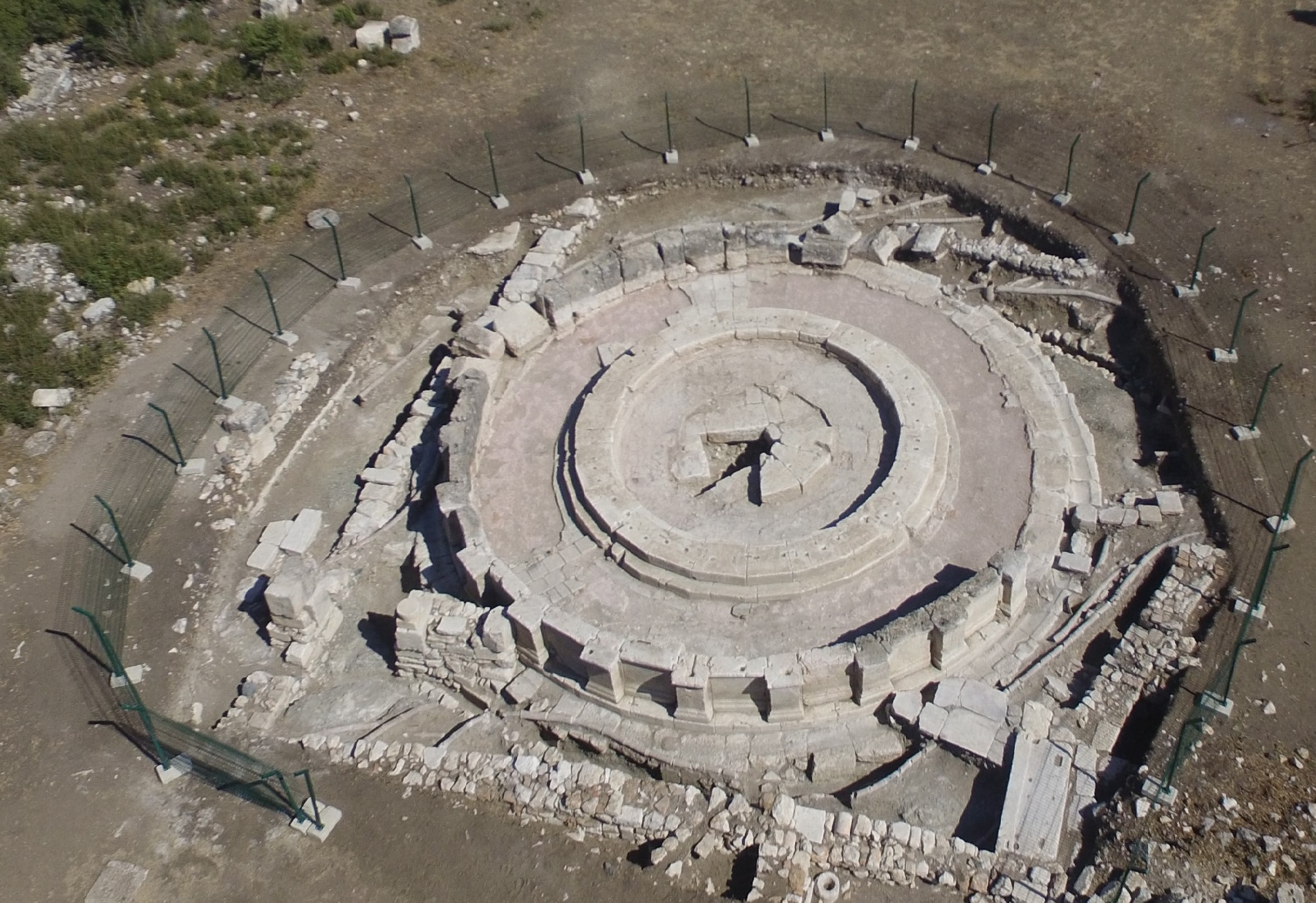
In the same years (1960-61), the Çavuştepe excavation in the Gürpınar Plain was also carried out by A. Erzen. Çavuştepe excavation continued until recent times. This city bears the name of Sarduruhinili. With its architecture, small finds and inscriptions, it yielded the most detailed and abundant material of the Urartian excavations in Turkey (Urartian fortresses were built on the tops of very high mountains).
Since 1964, excavations have been carried out under the direction of Prof. Emin Bilgiç and Prof. Baki Öğün at the Kef Castle near Adilcevaz on the northern shore of Lake Van. Particularly noteworthy are the basalt pillars with bas-reliefs uncovered in the palace section. Prof. Kemal Balkan also conducted research in the Patnos region near Lake Van. He discovered a temple belonging to King Menua and his son Argisti I at Aznavurtepe. A palace was also unearthed at Giriktepe. In 1965, British scientists Seton Lloyd and C.A. Burney conducted excavations at Kayalıdere near Varto, north of Lake Van. Especially the temple and tombs are remarkable. In 1967, Prof. Dr. Afif Erzen established the Van Region History and Archaeology Research Centre under the I.Ü.E.F.. The scientific board of this research centre began to investigate the Van Region in detail. Between 1971 and 1975, Van Castle and Toprakkale were researched again by Prof. Erzen, and rescue excavations were carried out on the hill where the treasure of Giyimli Village was looted and smuggled. Hundreds of bronze plates found here were smuggled to various museums and collections of the world. This assemblage of finds provides rich information especially shedding light on the last phase of Urartian art. In addition, rescue excavations carried out in the mounds in the Upper and Lower Euphrates basin under the name of dam excavations in Eastern Anatolia have provided new material and information on Urartian history, especially on the western border.
The excavations in the Van Region are currently being carried out again by I.Ü.E.F. In 1983, in connection with the historical national park project of the Fortress of Van and the Old Fortress of Van, headed by Taner Tahran, excavations were started at the Fortress of Van in 1987. These excavations revealed a large palace (Yenisaray) belonging to Argisti I. Excavations were also started on the mound (Van Kalesi Höyük) just north of the castle (dating from the EBA to the Ottoman period). In addition, the excavations at Dilkaya Höyük, carried out jointly with Ege University in 1984 under the direction of Prof. Atlan Çilingiroğlu, have continued until today, and excavations at the Urartian Castle-Ayanis were also started by A. Çilingiroğlu.
URARTU RESEARCH IN NORTH-WESTERN IRAN
In the last two decades, German and British scientific delegations have carried out excavations and researches in the settlement centres and fortresses in Northwestern Iran, which show the eastern expansion of the Urartian State. C.H. Burney conducted excavations and research at Hafvalan Tepe. W. Kleiss, one of the German scientists, conducted excavations in Bastam. The Urartu city here bears the name "Rusai Urutur" (small city of Russia). Nearly a hundred fortresses and settlement centres were found in Northwestern Iran, especially during the surveys conducted by the German Archaeological Institute. These cities constitute the settlements of the eastern expansion of Urartu in the VII century BC. Meanwhile, there are also small scale excavations and researches in Northern Iraq.
MAIN PERIODS OF URARTU HISTORY
In the light of contemporary historical sources and archaeological finds, the Urartians appeared on the stage of history from the first quarter of the 13th century BC to the beginning of the 6th century BC. In terms of geographical area, they were dominant in Transcaucasia in the Karasu Basin, with Lake Van as the centre, and in the lands extending from the Malatya Region to Lake Urmia. The history of Urartu is divided into two main periods according to the structural character of the political administration.
I. Main Period: It is the period between the first quarter of the 13th century BC and the first half of the 9th century BC. (Confederations period-Urartu's Archaic period).
II. Main Period: It is the period of the Urartu Kingdom between the second half of the 9th century BC and the beginning of the 6th century BC.
CHARACTERISTICS OF THE I. MAIN PERIOD
This period is characterised as the Proto-History of Urartu. Due to its characteristics, this period is defined by us as the Archaic Age of Urartu. The sources of this period are based entirely on the Annals of Assyrian Kings as written documents. In other words, the sources are unidirectional. When these royal annals are analysed, the Uruatri and Nairi Confederations - a union of feudal principalities that dominated the lands around Lake Van in Eastern Anatolia - are seen. The ethnic origins of these societies are based on the migrations of the "Huri-Urartu" tribes and related tribes coming from Transcaucasia in the third millennium BC. At the beginning of the 13th century BC, the main factor that led to the emergence of two major political unions, Uruatri and Nairi, which would form the foundations of the future Urartu State, on the stage of history in the form of a confederation of feudal principalities was a great and powerful danger emerging on the southern borders of Eastern Anatolia. As a result of the destruction and disintegration by the Hittites of the Hurri-Mitanni State, which dominated Northern Mesopotamia once in the vicinity of Kirkuk in the second millennium BC, this political power withdrew from the stage of history. The Assyrian King Salmanasar I (1274-1245 B.C.) dealt the last blow to the remnants of this state, which was struggling to survive. The chain development of historical events starts after this. With the disappearance of this state, this buffer state between Assyria and Eastern Anatolia disappeared. These events disrupted the political balance in Northern Mesopotamia.
This policy of Assyria, which has been trying to own the Eastern Mediterranean region and its trade throughout its history, and which has adopted the principle of exploiting the riches of Anatolian lands as a principle, begins to gain functionality with this event. The strengthening of Assyria necessitates a strong economy. The rich resources required for this were also available in Eastern Anatolia. For example, raw material resources such as iron and copper, soil products and animal herds as well as people. Heavy taxes and tributes levied on societies were a necessary and continuous source of income and exploitation for the Assyrian economy. When we analyse all the relevant Assyrian sources, it is understood that the real purpose of the military campaigns was for this purpose. In other words, economic reasons lie at the root of the campaigns against eastern Anatolia. There was no continuous and permanent Assyrian sovereignty for occupation. Thus, the independent feudal principalities in eastern Anatolia, which had no political unity until this date, were confronted with this strong danger coming from the south. As a result of this pressure, Uruatri in the first quarter of the 13th century BC and Nairi Confederations shortly afterwards took their places on the stage of history as a conscious counter reaction to Assyrian oppression.

HURRIAN-URARTU CONNECTION
It is certain that both societies are descended from common ancestors of the same origin. The migration waves of these related societies from Transcaucasia in the early 3rd millennium BC spread to two different geographical areas. a) Eastern Anatolia. b) Northern Mesopotamia, Northern Syria, Palestine, i.e. the Hirbet-Kerak Culture, which is the equivalent of the Karas Culture in Eastern Anatolia. These finding centres in Northern Mesopotamia, Syria and Palestine are also parallel to the distribution area of the Hurri language. This culture melted and assimilated into local cultures at the end of the 2nd millennium BC. It is a fact that the Hurrians who settled in the south had an advantage over the related societies settled in the high plateaus and mountainous regions of Eastern Anatolia. This is because the geographical environment, the level of civilisation of local and neighbouring cultures and mutual interaction should be taken into consideration. The Hurri culture in the south developed in the region where the super civilisations of the Asia Minor world were born. In connection with this, there are at least two major stages.
Writing
The Hurrians of the south, under the influence of well-established and high-level indigenous neighbouring civilisations, had a tradition of writing 1500 years earlier than their relatives in eastern Anatolia, the Urartians, as evidenced by the Hurri written documents from approximately 2300 BC and the following 2nd millennium.
Political Organisation
The Huris in the south, especially from the middle of the 16th century BC onwards, adopted a centralised state-kingdom administration. The existence of the administrative centre "Wassugani" and king names mentioned in the sources and the effective role of the Hurri-Mitanni State in Asia Minor prove this. On the other hand, in Eastern Anatolia, in the same period, local administration, i.e. tribal and feudal principalities were still in place. In conclusion, we can say the following.
Both societies continued their historical and cultural development in different geographical regions. For these reasons, differences have occurred in some cultural elements, especially in language. Urartu and Hur languages were close to each other, descended from common ancestors. Some Hurri texts dating back to the third millennium BC found in the southern regions show some features that continued in the Urartu language in the first millennium BC, but disappeared in the Hurri language in the second millennium BC. For this reason, the Urartian language is said to come from the prehistoric age of the Hurrians. Both languages are Asiatic. Urartu language is similar to the Ingush and Chechen languages, which are among the Caucasian languages of today. (Their ceramics are handmade. They started to use the wheel after they crossed to Anatolia).
URUATRI IN THE SOURCES OF SALMANASSAR I. (1274-1245 BC)
In his annals, the king of Assyria mentions a military expedition against the eight Uruatri countries surrounding Lake Van. (Uruatri=High Country, Mountainous Country= Assyrian texts). Following this, we encounter the name Nairi during the reign of his son Tukutti-Ninurta I (1244-1208 B.C. Tukitti-Ninurta Period). The aforementioned Nairi Principalities Union was formed in the lands west of Lake Van. Tukutti-Ninurta gives the following information in summary; 43 kings of the Nairi countries rebelled against Assyria, but they were bloodily defeated, subjugated and taken to Assyria in chains. The Nairi communities were subjected to tribute and taxation.
There is no information about Uruatri and Nairi in Assyrian sources until Tiglat-Pileser I, that is, until 1115 BC. In other words, the sources are silent on this subject. Because during this period, the migrations of the sea tribes in the west, followed by the Aegean migrations took place and the Mediterranean world was revitalised by these events. These migrations directly affected Assyria. However, its close neighbours, especially the western region, were greatly affected by these migrations. In this period of confusion, Assyrian kings undoubtedly did not want to leave their country by making an expedition to Eastern Anatolia. The migration of sea tribes is mentioned in the inscription of Egyptian Pharaoh Merneptah. Aegean Migrations took place at the beginning of the XIIth century BC. These are described in detail in the inscription of the Egyptian Pharaoh Ramses II in Medinet-Habu. Buckel (Memecikli) pottery from layer VII a of Troy also provides us with information. It is understood that the Uruatri and Nairi Confederations grew stronger and strengthened their sovereignty in this complex period.
URUATRI AND NAAIRI PRINCIPALITIES IN THE ANNALS OF TIGLAT-PILESER
(1115-1077 BC)
The campaigns of this king were especially directed against Nairi, that is, to the west and southwest of Eastern Anatolia. The account in his annal is as follows.
"Assyria, my God and Master, sent me to the distant countries on the shores of the Upper Sea, which did not have a master. I led their armies through narrow roads and steep gorges that no king before me had travelled through. When we advanced slowly, I rode in my chariot, and when the going became difficult, I advanced with the help of bronze axes. The 23 kings of the Nairi countries gathered their chariots and warriors in their countries. They came before me to fight. I attacked them with all the fury of my weapons, which caused fear and terror, and I destroyed great armies like the rushing floods of Assyria. 60 kings of the Nairi and those who came to their aid I drove by the power of my spear to the edge of the Upper Sea. I took their great cities, carried off their treasures and other booty, and burned their houses to the ground. I captured all the ktal of the Nairi countries alive, but I showed them mercy, spared their lives in the presence of Samas, my god and lord, and released them from the bosom of captivity. Then I made them swear before the great gods that they would serve and obey me in the future. I took their sons, the heirs of their dynasties, as hostages to keep their promise. Then I asked them to give them 1200 horses and 2000 cattle Tribut and gave them permission to return to their country again..."
It is clear that Tiglat-pileser I only wanted to exert pressure by plundering lands and riches, and to strengthen his authority in the Nairi Country by treating the captured lords well. In the following Assur- bel- kala period, the Uruatri and Nairi countries and the expeditions made against these countries are mentioned. Following this king, Assyrian sources are silent about Uruatri and Nairi for the second time. Because Aramaean migrations started. We have seen above that Assyria was able to stay away from the destructive effects of the sea tribes and the Aegean Migrations due to its geographical location. However, the desert tribes to the south of Assyria benefited from the confusion caused by these migrations, and Aramaean migrations of Semitic origin continued for years as a continuous leakage from the deserts to the cultural regions. Following these migrations, during the reigns of Adad Ninari II (911-891 B.C.) and Tukutti Ninurta II (890-884 B.C.), the Assyrian State once again turned towards Eastern Anatolia and made expeditions against the Uratri and Nairi Confederations and the societies there were again subjected to tribute and taxation. These confederations were freed from the pressure of Assyria due to Aramaean Migrations and became stronger.
THE FOUNDATION PHASE OF URARTU STATE
Since the Assyrian King Assur-Nasirpal II (883-859 BC), the terms Urartu and Nairi started to be used in the same sense in Assyrian sources. Especially in the History of Ancient Asia Minor, with this king, the middle of the century B.C. ). The mid-century is generally accepted as a period of intensified Assyrian military campaigns. In this period, it is noteworthy that Assyria regained its former military power as one of the superpowers providing political balance in the Asia Minor world. Assyria had gained control over the conquered territories through bloodshed, fire and force of arms. Their destruction and looting undermined the vital points of economic and cultural development. However, in response to these pressures, the resistance of the societies in Eastern Anatolia increased day by day and as a result, this time the Urartu and Nairi Confederations were united and the foundations of the Urartu State were laid. We call this period the foundation phase of the Urartu State. In other words, the Urartu-Nairi United State is in question. Detailed information about this is found in the annals of Assyrian King Assur Nashirpal II (833-859 B.C.) The first king of this united kingdom was Lapturi and is referred to as Lutipri (880-860 B.C.) in Urartian sources.
LAPTURI-LUTIPRI (880-860 BC)
The name of this king is mentioned in the inscriptions of the Urartian King Sarduri I in the capital city of Tuspa. In the Assyrian cuneiform inscription with the same text on the block stones of the monumental structure known as Sardur Burcu, located on the north-western end of the giant rock on which the castle of Van rises, Sarduri I refers to himself as "the son of King Lutipri the Great". King Lutipri is referred to as Lapturi in the inscriptions of his contemporary Nashirpal II of Assyria. Nashirpal II of Assyria, in his annal of the events of 882 BC, states the following.
"... during my stay in the city of Tushan ...... I received tribute from Lapturi, the son of Tubusi, and from the country of Urume in the same country, and I accepted chariots, horses, mules, silver, gold, bronze vessels, cattle, sheep and wine as tribute from the kings of the Nairi countries in the same country. I obliged the Nairi countries to carry it. ...."
Tusha is the city of Lapturi. It was captured by the Assyrian King Assur Nasirpal II and made a centre for the northern regions of Assyria and some of the Assyrian people who were impoverished by the Aramaean Migrations were settled in this rebuilt city. (Tuhsa = Üçtepe is a large mound.) A Kurkh stele was found here and taken to the Birtish Museum. Again, according to philologists, Lapturi is a typical Hurrian name.
ARAME - ARAMU (860-840 BC)
In the written sources of Assyrian King Salmanassar III (858-824 B.C.), another Urartian King, whose name is not mentioned in the Urartian inscriptions, is mentioned. In Salmanassar III's annal describing the events of 858 B.C., he says the following.
"At the beginning of my reign, in the first years of my reign.........I moved from Hubuskia (an important region south of Lake Van). I approached Sugunia, the city of the king of Arame of Urartu. I attacked and captured the city. I slaughtered most of his warriors. I collected the spoils. I made a column of severed heads in front of his city. I moved from Sugunia. I reached the sea of the Nairi country......."
In the events of the year of the reign of Salmanassar III (856 BC), it is stated as follows.
".....I travelled from the country of Daei ehi (around Erzurum) and reached Arzaskun, the royal city of Aramu of Urartu. When Aramu of Urartu was confronted with my powerful and terrifying weapons, he was frightened and left his city and went to Mount Ad. I slaughtered 3400 of his warriors and dyed the mountains and valleys with their blood like dyeing wool...."
In the fiftenth year of his reign, he organised his third expedition against Urartu (844 B.C.).
"....In the 15th year of my reign, I marched against the country of Nairi. I had a royal image of me placed at the source of the Tigris. I passed through the passage of the Tunibuni country and I pursued the cities of Aramu of Urartu to the banks of the Euphrates River...."

According to these concrete data, Aramu was definitely the king of the united Urartu state between 858-844 BC. However, Arame was not the father of Sarduri I, as the Sardur Burcu, the first known written document of the Urartu Kingdom, clearly shows. According to some scholars, there was a dynastic change when the kingdom passed from Arame to Sarduri I. The tribes loyal to Sarduri I probably took Aramu's tribes under their sovereignty and ensured that Sarduri I came to power. King Aramu succeeded in establishing a new organisation which was governed by a kingdom instead of a confederation. He strengthened first Sugunia and then Arzaskun and made these cities the administrative centres of the Urartu-Nairi Unified State, bringing the territory of the core country surrounding Lake Van under his control with these powerful royal cities. The destruction and looting of both capitals by Salmanassar III and the expeditions of this king against Urartu, the overcoming of mountains, the taking of booty and artefacts are vividly depicted in the bronze reliefs of the famous Balabat Gate, which is now exhibited in the British Museum. (This is the first pictorial document representing Urartu). However, despite taking such a measure, that is, despite the establishment of Arzaskun in a more remote region, it could not save itself from the destruction of Assyria.
SARDURI I (840-825 BC)
The powerful king Sarduri I, whose name appears as Seduri in the annals of Salmanassar III, is considered to be the true founder of the Urartu State, that is, the kingdom. In the 27th year of the reign of Salmanassar III, that is, in the events of 832 BC, he says exactly the following about it.
"......I gathered my chariots and riders together. I sent Turtan (Commander-in-Chief) against Daian-Assyrian Urartu. Seduri of Urartu learnt about it. Relying on the strength of his troops, he turned against me and was defeated in battle...."
However, it is understood that this was not a large-scale defeat. In the Assyrian cuneiform inscriptions, which are repeated six times on the block stones of a monumental structure called Sardur Burcu or Mother Burç, which is now called Sardur Burcu or Mother Burç, at the northwest end of the cliff on which the capital city Tushpa, that is, the magnificent Van Castle, which is understood to have been founded by Sarduri I, he identifies himself as the king of Urartu and says exactly the following.
".....The inscription of Sarduri, the son of the great King Lutupri, the mighty king, the king of the universe, the king of the land of Nairi, the king without equal, the terrifying shepherd who is not afraid of war, the king who destroys those who do not submit to him; I am Sarduri, the son of Lutupri, the king of kings, the king of kings, who accepts taxes from all kings. Sarduri, son of Lutupri, says: "I brought these stone blocks from the city of Alniunu, I built this rampart (wall)...."
G.A. MELİKİSHVİLİ, Urartskie Klinoobrazyne
Nadpisi, Moskova, 1960.
M.N. VAN LOON, Urartian Art: Its Distinctive Traits in
the Light of new Ezcavations.Lerden, 1966, İstanbul
B.B. PİOTROVSKİİ, Urartu : The Kingdom Of Van and Its Art. London, 1967
C.A. BURNEY, The Peoples of the Hills, Ancient Ararat and Caucasus London, 1971.